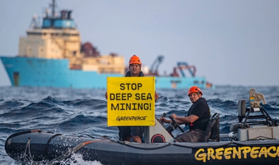
A total of 226 pollution patches were identified on the surface of the Black Sea between 29 April 2022 and 11 September 2025, covering an area of 1,308 square kilometres almost 5.5 times the size of Bucharest according to a marine pollution map launched on Friday by Greenpeace Romania.
Of these, 55 patches, totalling 162 sq km, appeared in protected areas, while 11 patches, covering 112.8 sq km, can be attributed to offshore oil and gas infrastructure.
According to a press release from the environmental organisation, Greenpeace Romania, in partnership with SkyTruth, launched the first interactive map based on satellite imagery on Friday, International Black Sea Day, showing the scale of oil and fuel spills in Romanian waters of the Black Sea.
Environmental activists described the overall picture as alarming: nearly straight streaks indicate spills from moving ships along main shipping corridors to and from the Bosporus Strait, while wavy patches, shaped by wind and currents, appear near oil and gas infrastructure.
The organisation also noted a worrying concentration of spills in protected areas such as the Danube Delta and the "southern lobe of Zernov's Phyllophora Field."
"Oil patches are often underestimated and receive little attention. Yet the discharge of wastewater contaminated with ship fuel and lubricants remains a standard practice, unfortunately. It happens regularly along the main shipping routes in the region to and from the Bosporus Strait. A new finding is the detection of leaks potentially originating from oil and gas infrastructure. Such cases of pollution are rarely reported in official statistics," said Alin Tanase, campaign coordinator at Greenpeace Romania.
Greenpeace Romania warned that these spills reduce water quality, disrupt the food chain, and endanger marine life, with effects that can be both local and cumulative. The map will be used to provide authorities with a precise overview of the situation in the Black Sea and to call for concrete measures to protect the marine environment.


"Using the Cerulean platform we developed, SkyTruth collaborated with Greenpeace Romania to verify over 200 oil patches in Romanian waters, arising from industrial shipping and offshore oil and gas infrastructure. After Cerulean's AI model detected potential patches, our experts manually analysed each satellite image to confirm the presence of oil on the sea surface using specific indicators. We then assessed the most likely sources based on ship routes and known infrastructure locations. Using satellite imagery to increase public transparency is essential for bringing accountability to the oil and gas sector. This analysis underestimates the scale of pollution due to gaps in satellite coverage," said John Amos, CEO and founder of SkyTruth.
Although satellite monitoring provides an unprecedented level of transparency, the results represent a conservative estimate due to inherent limitations in the imagery, such as weather conditions and satellite revisit intervals. The organisation is calling for proactive investigations into cases in protected areas and those linked to oil and gas infrastructure, including independent technical audits of existing platforms.
The map uses satellite images recorded by Sentinel-1 (SAR) and processed by Cerulean (SkyTruth) to identify anomalies specific to hydrocarbon films on the sea surface. All visible cases on the map were validated by Greenpeace and SkyTruth experts.
Greenpeace is an independent organisation that uses research, investigations, and public mobilisation to protect the environment. SkyTruth uses satellite imagery, artificial intelligence, and public data to make hidden environmental problems visible, measurable, and actionable.


Comentează